
 Like a surrealist's children's playground, Jantar Mantar was built next door to the remarkable royal Palace of the Winds as an astronomical observatory. Built around 1730 by the Maharajah of the famed Pink City, Jaipur, it was among the most accurate and detailed observatory for its time in the world. The star-inspired maharajah built five such observatories across India, four of which still exist today.
To the untrained eye, the structures look like creative and appealing oversized playground rides to climb and jump upon. With some description, they detail a fascination with accurate celestial measurements for the sun and moon, detailing the seasons, tracking the orbits of major stars, zodiac constellations and planets, predicting eclipses and measuring time itself. Importantly for the spiritual Indians, the observatory was utilised to satisfy an obsession with detailed horoscopes to ensure the best possible circumstances for weddings, major festivals, meetings and most aspects of life. The giant among the 30 or so structures is the 27 metre high Samrat Jantar (see background of second photo from the top)with its small covered deck for making relevant announcements. It is the world's largest sundial. The time remains extraordinarily accurate to this day with the cast shadow moving around one millimetre every second or one metre in just over quarter of an hour. You can literally see time move. The guide explains that it is angled at 27 degrees which corresponds to the latitude that Jaipur sits above the equator.
 Other equally strange structures include one with two large red disks also used to measure time and a strange structure like a cake with every second slice missing. It is able to measure the angle of the sun to assist with detailing the seasons.
 Jantar Mantar is a fascinating work integrating science, astronomy, religion and art. Particularly on a sunny day, wandering and climbing these strange stone travel wonders provides an interesting insight into the 18th century balance of science and spirituality.
Note
Jantar Mantar has been added to the UNESCO WOrld Heritage List in 2010.
Other India Posts
A Royal Facade (Palace of the Winds, Jaipur)
A Monument to Love (Taj Mahal)
From Dead Duck to Bird Heaven (Bharatpur)
Wednesday, October 29, 2008
It's All in the Stars (Jaipur, India)
Sunday, October 26, 2008
A Royal Facade (Jaipur, India)

Embedded within town walls, Jaipur is a harmonious city of broad boulevardes and unusual travel wonders. Today, the bustle of a huge population, manic traffic, enthused street vendors and meandering cattle overwhelms much of this harmony but the obsession with painting the buildings in shades of red (the city is known as The Pink City) still helps the city exude an elegant charm.
Most striking of all the buildings is the five-storey honeycombed Hawa Mahal or The Palace of the Winds. Over 200 years old and build from red and pink sandstone, this structure sits like a regal crown. With an exquisite carved facade boasting almost 1000 small windows, the fine stone latticework lets people see out (but not in). The light at different times of day changes the palace's moods changing its colour from golden bronzes to riotous reds. The surprises lie behind the scene. Walking through a large courtyard, it is clear that this building is only one narrow room wide, more like a five-storey honeycombed wall than a palace. Walking to the top floor via ramps (there are no staircases), you can peer out of the tiny grills onto the vibrant city below. General belief is that this was built for the women of the royal household, who could view the city parades and other activities while keeping hidden from public view, their lives being led under very strict rules of modesty.
Today, the brazen monkey inhabitants steal the best views, keeping a watchful gaze over their domain. They seem somewhat affronted having people wandering through their regal surroundings, though any chance to pickpocket an unwary visitor of food or other items is quickly grabbed.  On the street below, the snake charmers beguile the tourists and locals alike with the cobras rising from their woven baskets and swaying to the mournful music. Similar to their backdrop being a palatial facade, their act is also somewhat of a facade. The cobras have been de-fanged and the swaying following the path of the gently rocking charmer, rather than dancing to the music. After all, the snake cannot hear the music!
 Whether a facade or not, the Palace of the Winds is a stunning royal building with its intricate carving and excellent views over the mesmerising Pink City of Jaipur.
Other India Posts
A Monument to Love (Taj Mahal)
From Dead Duck to Bird Heaven (Bharatpur)
Thursday, October 23, 2008
Underground Fantasy (Skocjan Caves, Slovenia)

Carved out over millennia by the broiling Reka River, Škocjan Caves is Slovenia’s most stunning natural travel wonder. This river disappears underground in the little village of Škocjan and emerges some forty kilometres away, having carved its path through the rock over many years.
A large area of south-west Slovenia lies on a limestone plateau. Incredible caves and tunnels have been eroded from the soluble limestone, leaving a fairyland of richly coloured and unusually shaped stalactites (the ones that drop from the roof) and stalacmites (the ones that grow from the floor). Out of all of these, UNESCO-listed Škocjan sits at the very pinnacle of these subterranean treasure troves. Awkward to get to, easiest is a walk of a few kilometres from Divaca rail station on a pleasant path to the hamlet of Matavun. The area contains some great short walks (especially the Educational Trail) through some local villages and around collapsed cave areas. There is a small museum showcasing the cave’s history which helps pass the time till the guided tour is due.
 The cave starts modestly through a longish tunnel and through a number of chambers with a variety of typical cave decorations and formations, the most notable with the typical imaginative names. Early on, the tour traverses Silent Cave, Paradise Cave and the impressive Great Hall and witnesses The Organ (which looks a little like a church’s pipe organ) and the Stone Forest.
 As the tour exits the Great Hall a deep-throated rumbling can be heard from below. The Reka River lies around fifty metres below and is dwarfed by the immense Murmuring Cave – 300 metres long and over 100 metres high (which means that the Statue of Liberty or London’s St Paul’s Cathedral would fit inside). It lays claim to being the world’s largest underground canyon. Walking gently along a narrow ledge, the tour comes to the vertigo-inducing Cerkvenik Bridge (lead photo). Defying the considerable degree of edginess and shaky legs and leaning nervously over the bridge, it is beyond comprehension to imagine the raucous river below could have carved this cavern for giants by dissolving minute particles of limestone.
The previous bridge and the remains of the earliest bridge can still be clearly viewed and paths to various other caverns and halls branch off for the professional cavers and scientists. Moving along, the next section includes a mesmerising formation called The Bowls. A series of a over a hundred natural troughs of water have built up over time, filling and emptying into the bowl below, leaving tiny mineral deposits to construct the walls of these mini-reservoirs.
Soon after the eyes squint as the daylight streams through the natural cave entrance created when the roof of an area collapsed and onto a funicular to save the legs from having stagger back up the hill.
The world contains numerous limestone caves, all fascinating in their own way but Škocjan stands as one of nature’s finest travel wonders – a subterranean wonderland of unimagined scale, breathtaking chambers and magical formations.
Notes
Photography is not permitted in the caves. Cave photos are sourced from an online gallery and a brochure. Other photos are available from the cave’s website.
Other Central Europe Posts
Bountiful Bled (Slovenia)
Aquamarine Necklace (Plitvice Lakes, Croatia)
Personal Space (Halstatt, Austria)
Hiking the Confection Villages (Cinque Terre, Italy)
Tuesday, October 21, 2008
Photo of the Week - Osprey Family

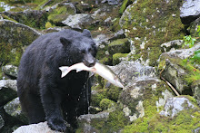
 Driving around in the Rockies, we spotted a number of cars stopped on an innocuous river bridge. Curiously, we turned off to see what was happening to find a family of ospreys nesting and regularly feeding from the river below. Mum swooped majestically to pluck a fish from the chilly waters below. The youngsters weren't yet fully fledged but were starting to flap their wings. Their sharp eyes swept left and right, patrolling the environment viewing the camera-wielding humans with suspicion. What a great place for a nest.
Other Recent Wildlife Photos
Mountain Gorillas
Toucan
Marmot
Top Ten Wildlife Travel Wonders
Saturday, October 18, 2008
A Real Voodoo Experience (near Ouidah, Benin)

The truck driver said that it was only half a kilometre down this rough dirt track. Distance was often a vague concept in this part of Africa and I could only hope that he was accurate. It was only nine in the morning and already a searing day. As we walked, debate was strong on whether this one of our more stupid ideas or a trip highlight.
In the main city of Ouidah, this small village came strongly recommended as a good place to see an authentic voodoo ceremony. Most people questioned thought it a strange request and looked at us oddly, but the story seemed to check out fairly consistently.
After an hour of walking (well beyond the estimated half kilometre), shirts drenched in sweat and legs caked in dust, we ventured apprehensively into the village and asked for the village elder. We gave him some eggs and vegetables as gifts bought at the local market in nearby Ouidah and were invited to stay and view the ceremony. Disappointingly, there was to be absolutely no photography (something to do with the spirits) but the welcome was overwhelmingly friendly. Though being the only westerners, it seemed the chief’s blessing made the entire village open and friendly.
The mere mention of voodoo back home conjured up images of the occult, black magic, juju men, pins being stuck into dolls and human and animal sacrifice. I guess there were small elements of some of these aspects, but voodoo appeared far deeper and more spiritual. The Ouidah markets were full of fetishes for sale including animal foetuses and skeletons of local wild animals. The sight of crocodile or monkey skulls glaring back was upsetting but remains an active ingredient into the population’s life.
Locally, they called it vodoun, being an official religion of Benin and Togo. An estimated 60 to 70 percent of the population follow some variant of vodoun. With the slave trade, this religion migrated to Haiti, Cuba, other Caribbean islands and parts of USA and Brazil. Somehow, it was renamed to voodoo during the migration.
Directed to some elegantly woven straw mats, we sat spellbound as offerings of food, chickens and blood to appease the spirits were made. These spirits governed the villager’s life, providing sustenance, good weather, protection and well-being. The vodoun ceremonies appeared to serve multiple purposes from celebrating the birth of a child, a wedding, significant dates, successful crops and to ward off bad omens.
After the offerings, the women started to dance to the rhythmic beating of drums. Slowly first, dust sprayed from the rapid-fire steps and swaying of the bodies, the dance growing ever more energetic and vibrant. The dance culminated with the women shaking uncontrollably, consumed by the spirits. Arms flailing helplessly, they lost control of their bodies before being guided into a spiritual hut. Several women went through this same experience as the sun sank lower in the sky. Thanking the chief before returning to Ouidah, priests had prepared some potions for us (for a modest fee!), their benefits hidden by a deep-throated French explanation. We paid him and departed, somewhat alarmed at the thoughts of what could be inside these wrapped leaves.
We never rubbed the strange ashen offering into our skins nor kept the tiny objects, but left uplifted and bewildered by this complex spiritual experience.
There was almost no conversation on the road back to Ouidah, both lost in our own worlds having lived a day in a completely different world.
Notes
In respect, no photos were taken that day.
Photo Sources: 1,2
Wednesday, October 15, 2008
Photo of the Week - Tombstone in Tombstone (Arizona, USA)

 Tombstone lies in the south-west of the United States not far from the Mexican border. With only a population of 1500 people, it still dines out on its most famous incident with the gunfight at the O.K. Corral. Indeed, you can be photographed with the main characters from this gunfight (for a fee of course!). Though far more sedate, its main street still has many reminders of those times with its dusty streets and sprawling saloons.
Nearby is a rugged but moving cemetery with hand-painted grave markers with some great remarks including those photographed above. Life was less certain in those times as is described by the pithy poem about poor George Johnson who was wrongly hanged.
Other Photos of the Week
Mountain Gorilla (Africa)
Dye Pits (Morocco)
Remote Sign (Iceland)
Bad Hair Day (India)
Icy Hoodoos (Bryce Canyon, USA)
Sunday, October 12, 2008
Exploring the Incan Wonderland - Part Two (Machu Picchu, Peru)

See Part One for an overall description of Machu Picchu (Inca Trail trek described here) and a guide to the some of its attractions. A quick-guide map is repeated below (taken from Huayna Picchu) to guide you around the site.
 The sacred district has the most significant and ma sites of the complex. Walking from the Temple of the Sun towards Huayna Picchu, you arrive at the Principal Temple (PT on the map). This three sided temple boasts some beautiful stonework (though some has subsided with earth movement) and an elegant stone altar. In this same area is the equally
 distinctive Three Windowed Temple (3W) with characteristic trapezoidal-shaped windows and superb stonework. Note the rock on the near side as part of the closest window has ten sides, yet fits neatly like the most perfectly formed jigsaw.
A little further uphill and up a regally carved stone staircase is the most remarkable element of Machu Picchu  is Intihuatana (IN on the map). Nearly always surrounded by large groups, it is a style of ancient sundial. To show the Incan’s deep understanding of astronomy, calendars and agricultural cycles and their precision stonework, this diamond shaped rock casts no shadow only at two time points during the year - midday on the two equinoxes (March 21 and September 21) – the sun shining directly onto the rock. Even the guides who tell the same story every day seem to be moved in describing this stunning piece of middle age engineering. It is also claimed that the four points of the diamond lie to the four main compass points and are directly aligned with four of their most sacred mountains including Veronica to the east (photographed in an Inca Trail post) and Huayna Picchu to the north.
 Walking to the end of the site is the entrance to the climb of Huayna Picchu (Young Mountain). It is a steep, vigorous climb up lots of rough Incan stairs and uneven dirt paths and takes between one and two hours (depending on your fitness). It is a well-worthwhile walk (after all, how often will you be in this majestic location). For the trekkers, encourage those tired legs to undergo one more climb. It must be undertaken in the morning (closes in the early afternoon and has daily limits on the number of trekkers) and is best recommended for the start of Day Two for those who are visiting for two days (strongly recommended approach). The view from the top gives a great understanding of the layout of Machu Picchu, offers an awe-inspiring overall panorama of the Andes and highlights the impressive terracing of the agricultural sector (see the lead photo of part one). Parts of this steep-sided mountain are terraced too.
If you aren’t yet tired of walking, a side path takes you to the impressive Temple of the Moon. Finally, once you are down, I’d suggest you spend time wandering the general urban area (H on the map) where the standard population lived. Many of the houses are still in fine condition, though there are no roofs left as they were made of branches and grasses.
There are numerous other temples, rooms and areas to wander and get lost in this fantasy world of extraordinary stone buildings of the middle ages. Spend time relaxing in the main grassy plaza area and contemplate what a time it must have been, the hub-bub of activity in daily Incan life.
Whether you are mesmerised by the temples, the water-channelling system, the unusual stone sundials, the dry stonework of the walls, the large-scale agriculture or the phenomenal natural mountain setting, the Incan creators have left a remarkable legacy of an awe-inspiring, haunting, mysterious and magical travel wonder in this lost city.
Other Peru Posts
Trekking to the Lost City (Inca Trail)
Flight of the Condor (Colca Canyon)
Living in Reeds (Lake Titicaca)
Top Ten Travel Wonders of South America
Photo of the Week (Toucan)
Wednesday, October 8, 2008
Exploring the Incan Wonderland - Part One (Machu Picchu, Peru)

UNESCO-listed and one of the New Seven Wonders of the World, the “lost city of the Incas” at Machu Picchu (Old Mountain) is simply one of the world’s greatest treasures (and my number one South American wonder). It setting of over 150 buildings constructed across a verdant Andean saddle along with a feeling of mystery and awe, it is one of the world's most uplifting and haunting travel wonders. Being able to walk into the complex at dawn via the famed Inca Trail adds to its feeling of majesty. Machu Picchu is estimated by some scientists to have supported a population of up to 10,000 people. Its structures included temples, houses, agricultural terraces, fountains, water channels (which still work today as pictured) and open-air plazas. Not plundered by the raiding Spanish in the middle ages, it remained hidden to western explorers until early the last century.
Machu Picchu becomes much richer for having a guide explain the structures and layout. Indeed, most will make little sense without some detailed explanation which will add to the extraordinary nature of this incredible civilisation. Hopefully a photo map (taken from Huayna Picchu, the mountain that looks over the entire complex) will give a bit of an idea of its layout.  With an overall shape of the sacred condor, Machu Picchu is split into the agricultural sector (AS on the map) and the urban sector where everyone lived. The agricultural area is reputed to have been able to support up to four times the population, so it was well planned. The terracing clearly reduced erosion on the severe slopes of the mountain top. It must have been some feat to convert these sheer slopes into garden areas.
You can only get to Machu Picchu by foot (see Inca Trail story) or train. If you arrive via trekking, the path leads from the majestic Sun Gate through the agricultural sector (SG on the map), past the watchman’s hut (which probably served as a guard house in Incan times and is a great spot for a photo of the complex) and into the urban sector.
The urban sector is divided into three major areas – the sacred district, the noble district and the residential district. The first area that you walk through is the noble or royal area which provided housing for the better classes (leaders, priests and rich people). The houses are bigger and generally built with better stonework. The structures and standards of construction are awe-inspiring. Note the huge rocks and consider how difficult it must have been to get them to Machu Picchu. The rock walls are built without mortar and are so perfect that it is impossible to slide a knife or credit card between the bricks. In some of the temples, the rocks are oddly-shaped with many sides, but still have the same perfect fit.
Beyond that, the walls are not straight but slope slightly into each room. Similarly doors and windows are built narrower at the top than the bottom creating a trapezoidal shape (for the mathematicians among us). Scientists speculate that the lack of mortar and the use of the trapezoidal walls and doors helped preserve the site from the many tremors and earthquakes that strike this geologically active area. To realise that the Incans understood all this and had the capacity to build such perfect structures is a testament to their remarkably advanced culture. Adding to the remarkable construction is the Incans fine awareness of the stars, sun, moon and their linkage to the annual calendar. A number of the structures are precisely aligned to the equinoxes (around March 21 and September 21) and summer and winter solstices. This was highly important for the timing of planting of crops as well as having religious significance.
 As soon as you enter the urban sector from the trek, you will notice the careful harnassing of water in a series of baths, fountains and channels. The water channels continue to work to this very day and are thought to have provided clean water to the entire complex including many of the individual houses.
  Nearby is the only round building in the entire complex is the Temple of the Sun (TS on the map - two photos above). It was clearly significant as the stonework is superb. One of the windows aligns perfectly with the summer solstice.
Below the temple is a niche called the royal tomb (RT) though no tombs exist there (photo right).
See part two to further explore this Incan travel wonder.
Sunday, October 5, 2008
Trekking to the Lost City - Part Two (Inca Trail, Peru)

See part one for details of the first two days of trekking the Peruvian travel wonder of the Inca Trail.
Day Three is the longest trekking day (around 16 kilometres or ten miles) but it is mainly downhill over uneven ground (which is surprisingly hard on sore legs) and in many ways is the main highlight of the trek (apart from Machu Picchu itself). The trail passes some majestic Incan ruins.  Sayaqmarka (“Inaccessible Town”) perches on a small hilltop, formidably protected with cliffs on three sides and a narrow stairway on the fourth. It features a number of semi-circular buildings, rooms and squares on different levels connected with narrow paths, ritual baths, flat open areas and canals. Despite the misty morning our group incurred, you could make out the rest area it must have provided Incans travelling to Machu Picchu and the strategic oversight it offered over this key pathway. Some of the unequalled precision of the Incan stonework is featured, built without mortar, but with such perfect joins that you can’t slide a pocketknife into the gap.
 Trekking follows the original Incan path down into the valley and up to the third and gentlest of the three passes. It passes through an Incan tunnel with smooth walls and carved steps – an incredible engineering feat given the limited tools available at the time.
 Phuyupatamarca includes a terraced area for crops and six Incan baths probably associated with religious rituals. The trekking from here on is on the original Incan staircase and follows over 1000 uneven stone stairs (downwards) through a cloud forest of lichen-strewn trees, orchids and ferns in a cool refreshing atmosphere.
Late in the day and near the final camp site, there is a stunning terraced agricultural area along with a residential complex at Wiñay Wayna (lead photo and below), which roughly translates to forever young. A series of fountains run from the top to the bottom of the slope in a perfect alignment with the terraces. The Urubamba River that we crossed at the start of day one continues to flow below. Day Four tends to start early for a short walk (about an hour and a half) to the Sun Gate (Intipunku) which oversees the entire Machu Picchu site. As if uplifted by a mystical power, people who could barely take another step over the previous two days approach a sprint as the trekkers herd towards the Sun Gate at dawn. Surrounded by magnificent scenery, the peaceful walking of the previous three days is lost in this final undignified crowded surge towards the Incan sanctuary.
The crowd awaits the sunrise. Everyone speaks in excited but hushed tones and there is a huge sense of satisfaction at completing this holy grail of trekking. The hardship of walking the last three days had all been worth it. A few alpaca and llama contentedly graze below, familiar with the daily pre-dawn commotion. The mountain saddle which Machu Picchu is built upon tends to be misty but when the foggy curtains lifts, the truly awe-inspiring and haunting travel wonder of the “lost city” of the Inca unveils before your very eyes.
Now for a tour of Machu Picchu itself...
Other Peru Posts
Flight of the Condor (Colca Canyon)
Living in Reeds (Lake Titicaca)
Photo of the Week (Toucan)
Thursday, October 2, 2008
Trekking to the Lost City - Part One (Inca Trail, Peru)

 Our small group is half way through day two and we reach the high point of our Camino Inca trek on the evocatively named Dead Woman’s Pass (trail map). Breathing heavily in the rarefied air at 4,200 metres, our spirits lifted when we discovered that this was the highest point in our walk. Three hours earlier, most of us were regretting signing up for this famous four day venture to the Incan “lost city” of Machu Picchu (my number one South American travel wonder). Looking back, other trekkers are hunched forward, heads down, slowly trudging up the steep slope. They dare not look up at the distant goal ahead for fear. They are probably sharing the same regrets but refuse to be daunted by the steep featureless final slope and plough on.
Mind you, there is a strange feeling of privilege in walking on the same paths as followed by the Incan Indians some five hundred years ago. The mountain vistas, cool, clean air and patches of refreshing forest keep the spirits going when the legs become unwilling and the body flags.
By contrast, the guide and porters are making easy passage. Shod only in old sandals made of car tyres, they have walked it many times before and despite being weighed down with our packs, food, clothing and tents, they seem to enjoy tracing the steps their ancestors took, five hundred years earlier. I walked the trail several years ago but today the government have placed a strict daily limit of 500 people (counting guides, porters and tourists alike) on the trail to help protect this ancient Incan highway. The officials seem to be battling a delicate balance between the lure of the tourist dollar and preserving the very thing attracting these tourists. This means you have no option but to book some time ahead to ensure that you can get access to one of the most famous treks in the world. You must walk the trail with an official operator and you cannot join at the last minute (the agencies have to register the names several days in advance). This is something that you need to be organized for. As a rough rule, there will be between one and a half to two guides/porters/cooks for each paying walker and all rubbish walked in must be walked out. It is a travesty that plastic water bottles litter the path in some places – all of us must play our part to preserve this remarkable heritage area.
There are a number of different walks. This post describes the best known and highly recommended four-day “Classic” trek but there are one-day, two-day and seven-day versions as well. The trail passes some thirty different Incan sites and is surrounded by spectacular Andean mountain backdrops. Yesterday, we started this journey in high spirits for a short train ride from the lively village of Ollantaytambo, itself rich in Incan structures and possibly the best preserved Incan town of all. Alighting at the drearily named Km88 (representing the distance from Cusco) with our group of six eager trekkers and guide, around nine porters and cooks organise their loads in good spirits. There is a strict code to ensure that everyone carries an even share and that the loads don’t exceed an agreed weight.
  Almost immediately we cross the Urubamba River over the appropriately named Bridge of Happiness and walk at a brisk pace, locating the first of numerous Incan sites at Llactapata, an Incan residential site. Day One is twelve kilometres (eight miles) long with a slow ascent for the second half of the day. Camp areas vary but we stayed with a superb valley outlook, the towering snow-capped peak of Salkantay and Veronica (lead picture).
 Refreshed from resting on Dead Woman’s Pass, we started our descent, falling away into the Hidden Valley and back up to a milder Andean pass at Runkurakay, an Incan watchtower, animal shelter and food store. Dinner is enjoyed viewing the incredible valley vista under the light of a gleaming full moon, before we all head for our tents - the soothing sound of a tumbling waterfall easing us into our evening slumber.
This world famous trek continues in part two.


